Process-based Adaptive Watershed Simulator (PAWS)+CLM
Background information Today's water resources problem is one convoluted by rapid global change and complex interplays. Predictions must be made at various spatio-temporal scales, beyond previous observed range of variability [Wagener 2010, WRR], under new sets of norms and in the context of strong feedbacks. Understanding and predicting hydrologic responses and their feedback on climate and other subsystems are of both scientific value and socio-economic urgency. As an effort to help tackle water resources problems in the new era, PAWS was initially developed as Dr. Shen's Ph.D. dissertation topic at Computational Hydrology and Reactive Transport lab, Michigan State University, with help from labmate Jie Niu. PAWS was developed with three key features in mind: 1. Comprehensive, physically-based governing equations: these equations (e.g. Richards Equation) are derived deductively from established physical laws and able to reproduce lab/field observations. Channels are explicitly represented. |
 |
PAWS is now fully coupled to the Community Land Model (CLM) 4.0 , encompassing comprehensive land surface processes including surface heat/momentum/vapor transfer, surface radiation balance, snow/soil heat transfer and freeze-thaw phase changes, photosynthesis and plant growth, as well as carbon and nitrogen fluxes, mostly using process-based descriptions. ([Shen 2013, WRR]). PAWS+CLM also provides a practically easier access to CLM functionalities, executable on either Windows, Linux or Macintosh machines. |
|
| Vision of the group We are interested in constantly integrating process-level descriptions, including wetland, desert and mountain processes, etc, novel datasets, and improved algorithms. We strive toward a trans-disciplinary tool that provides a synergistic platform for process scientists, field scientists and modelers from a wide range of disciplines to confluence in the context of accurate hydrologic predictions. Such a platform helps us examine separate processes in a broader context and identify undiscovered yet profound linkages among hydrology, ecosystem and human socio-economic dimensions. 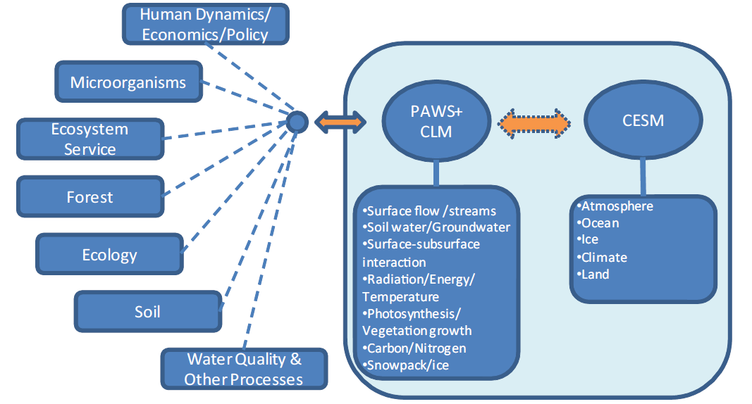 Internally, we will ensure its active coupling to CESM (Community Earth System Model) which provides access to coupled atmospheric and climate modeling. Collaboration can be done in various forms including in-house development, model integration or data interactions. |
|
Model structure PAWS was created with intermediate complexity, GIS data interface and parameterization functionalities. The model solves the governing equations for major hydrologic processes (surface-subsurface flow, river network, wetlands, vegetation and snowpack, etc) efficiently using efficient, stable algorithms and a large-scale surface–subsurface coupling scheme. To know more about PAWS and PAWS+CLM:
|
|